Showing posts with label maps. Show all posts

Thursday, December 13, 2012

EarthClicks

Its extremely impressive how far Google has come with its technology advancements; whether it's Project Glass, Google Fiber or the Google Driverless Cars. None of these new technologies are available to the general population yet, but it will certainly change the way we live our lives, whenever they get launched.

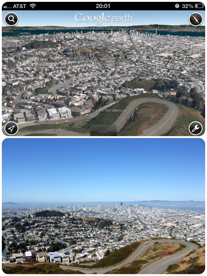
One technology that was launched years ago but still blows out my mind is Google Earth. As with all other Google products, this masterpiece has improved in features and performance, year over year. The cool addition of 3D buildings and 3D terrain maps on iOS/Android version of the Google Earth App has impressed one and all. It has given each one of us wings to fly to any part of the world and witness the spectacular views made by man and nature.

This app on my iPhone gave me the idea to use the Google Earth App and recreate the scenes depicted in the pictures that I have clicked over so many years. Here's the first such creation of mine of the Twin Peaks. Let's call them EarthClicks.


Friday, March 14, 2008

What if Google Sky was launched a Century later

Google recently launched another mind-boggling yet completely-useless-to-common-man tool called Google Sky. Here's a snapshot:


What if this product was launched a century later? There would have been just one minute change in the UI which would have made it really useful in that age:

Monday, May 28, 2007

Longest day of my life (BLR-LHR-SEA)

0824 PDT, 28th May 2007. Seattle, WA.

You must have heard the phrase "being ahead of time". I just experienced it, when I flew from Bangalore to Seattle via London. I left Bangalore at about 0245 IST in my cab as I had my flight at about 0630 IST. It was pretty cool in the night and I was feeling damn excited about the trip.


The British Airways flight left on time. As always, I was unlucky enough to have an old fellow besides me. There was an empty seat between the two of us and I kept hoping someone 'interesting' would show up. But alas, it never happened. Anyways, I was more interested in sleeping at that time (Just to clarify, when I said 'sleeping' I meant 'dozing' and had no other malicious intentions).


The flight seemed pretty long, probably because I could hardly sleep. However I could see some really beautiful views from top. We flew over Dubai (check the snap above) and Mainland Europe before landing at Heathrow, London (LHR). The flight was delayed for about half an hour or so. That forced me to hurry to catch the connecting flight. I managed to finish the formalities just in time! I wanted to call up a few friends in UK but unfortunately I just couldn't.


After spending a few minutes in the Terminal 4 of LHR, I boarded the BA flight to Seattle. This time as well I didnt get to sleep much. Not because of any disturbance of any sort but because the view from the top was simply breath-taking.

We flew over Iceland, Greenland (see the snap above), Canada and finally landed in Seattle. Yippeeee!!! I have reached the country of dreams!!!

Gotta go now. Its Memorial Day here (an off day) so gotcha see some cool places around. Till then you can enjoy the pics I clicked on the Longest Day of my Life...


Picasa SlideshowPicasa Web AlbumsFullscreen

Sunday, April 8, 2007

Flash Earth

With the Map APIs being exposed by various service providers, there has been a fresh new surge of map applications in the web. One such new product is Flash Earth.

Its a typical Flash-driven Mashup which makes use of feeds from 8 sources: Google Maps, Microsoft Virtual Earth, Yahoo Maps, NASA Terra, etc. The user can select any of the above mentioned feeds. The navigation features are very similar to Google Earth; like zooming using the mouse wheel, click and drag, etc. The 'Search a Location' panel on the bottom-right of the screen is neat and quite accurate, along with latitude/longitude coordinates and the ability to save URL’s for exact locations.

Two features make this web application a winner

1. No external client is required to use all of Flash Earth’s features. All you need is a Flash-equipped web browser (I was able to run the application successfully on Firefox 1.5, Firefox 2, and Internet Explorer 6 and Internet Explorer 7)
2. Maps fill the whole browser window. No more navigating tiny and awkward frames, combined with the smooth zooming effect, Flash Earth handles like a regular desktop application.

Over all a great web product.

Thursday, April 5, 2007

Google launches My Maps

Online search giant Google today added an extra feature to Google Maps to simplify the creation of maps mash-ups so users can quickly share the results.

My Maps, based on the concept of "create and share", will democratise map making in a profound way, Carl Sjogreen, Google ANZ senior product manager, said. A mash-up is a Web site or application that combines content from a variety of sources into an integrated experience.

Users, once logged-in, can embed videos from YouTube, text, photos or anything from a Web page, as well as draw lines or shapes and mark locations with icons to personalise their map. It's the first time that Google has offered such functionality -- including customised map drawing tools and links to other Internet content -- within Google Maps.

Once a map has been created users can share the map with family and friends, or make it available to anyone trawling the World Wide Web by making it public.

Sjogreen believes My Maps is easier to use compared to existing mash up sites already using Google Maps API (application programming interface) which offer similar experiences -- customised maps with rich embedded content.

The ability to search My Maps is not yet available, however, Sjogreen said the capability will be added in two to four weeks. Google is currently developing algorithms to rank the most relevant maps in a search query.

My Maps is available in 10 countries and can be accessed at http://maps.google.com.